
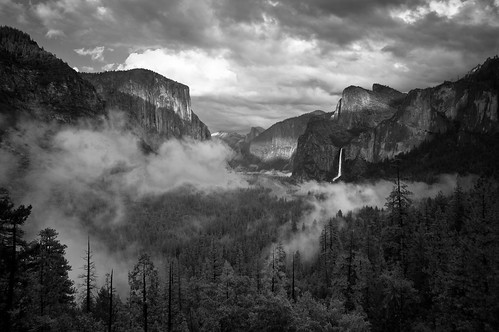
Evening Light, Tunnel View Overlook
After the somewhat guilty luxury of a wonderful dinner and drinks the night before, we had outlined our fifth day in the Park. We planned to slip the bounds of the Valley and its crowds and set out into the wilds of the Tuolumne Meadows area. It was a fantastic plan, with times and designated hikes, and probably even hand drawn illustrations.
Then the rains camei.
Starting the night before, it had begun to rain with an atmospheric vengeance heretofore reserved for Biblical events. As the night wore on, storms thundered up and down the valley. Lightning came in such quick succession that the sky seemed to never darken. Echoing between the valley walls, the thunder seemed to roll from one end of the Valley to the other, roaring overhead throughout the night. It was almost impossible to sleep in the sheer fury of the storms passing over us.
It was at this point my previous regret at tent-cabin camping instead of “proper” primitive tent camping, evaporated completely. Sadly, it was about the only thing that evaporated. We had strung upii a few lines to dry some clothes, but the humidity inside (and outside) the cabin was enough to prevent anything from drying, even when the rain tapered off by morning.
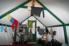
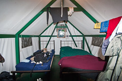
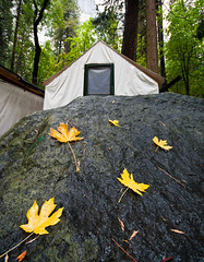
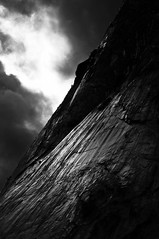
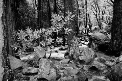
Damp Cabin – facing out, Damp Cabin – facing In, Our Doorway…with Entry Rock, Morning Stormlight on Rock Face
During the night we assumed our Tuolumne Meadows plan was shot, but the storms had abated by morning, so we set out with a spring in our step like prisoners given an unexpected reprieve.
Then plans changed again…
I had set out to get some coffee while Kate was getting packed up for the day, and happened to stop by the Village office to check on conditions. Unfortunately, what we had experienced as cold rain in the Valley was apparently driving snow at the higher elevations. Tioga Pass, the high elevation route to the alpine Tuolumne Meadows area, was closed. Just like that, the plans we had just retrieved from the waste bin got crumpled up, thrown back in the bin, and figuratively set on fire. So, much like a GPS unit after a bad turn, we were recalculating.
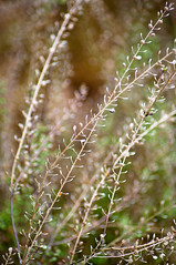
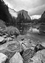
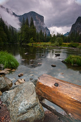
The rain did give an unexpected boon, however. The falls that had been dry or near dry previouslyiii were now gushing torrents. We debated about it, but ended up going back to Yosemite Falls and Bridal Veil Falls. It was well worth it, as what had been miniscule trickles were now a truly outstanding experience. It seemed as if an entire ocean was continually threatening to crest over the Valley ridges, coursing down in violent rush to the rocks below. We took the time to walk through the Yosemite Falls area, seeing the location of the woodworks at which Muir had been employediv.
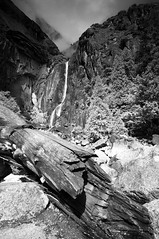
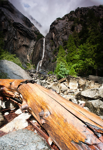
Upper Yosemite Falls, Yosemite Falls From a Distance, Tree Among Rocks, Lower Yosemite Falls Study #15, Lower Yosemite Falls Study #6.
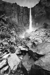
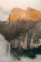
Bridalveil was running so mightily that it was almost painful to stand in the spray at its base. I got some nice photos, but at the cost of a completely soaked camera and a completely soaked me. We also spent some time walking around Cook Meadow, whose colors were vibrant in the diffuse light, and stopped along the Merced for (photo wives, this is your cue to sigh and roll your eyes) some more photography that morning before the falls.
Cook Meadow
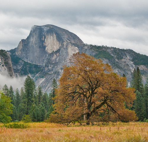
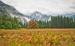
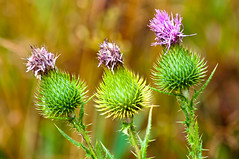
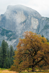
Half Dome with English Elm, Meadow Vista, Thistles, Half Dome and Tree, Meadow grasses
Merced River Vista
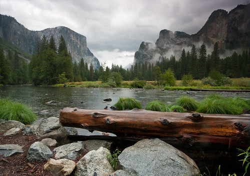
Merced River Vista Study #6, Merced River Vista Study #2 Rock and Wood- Merced River
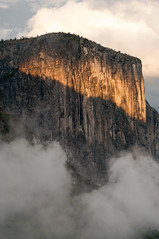
Bridalveil Falls
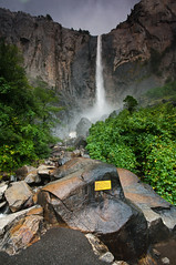
Bridalveil Falls with Plaque, Dogwood at Bridalveil Falls outlet
We were running low on gas, and since we were leaving the next day, decided to fuel up before the end of the evening. Unfortunatelyv, of all the amenities that the Valley has, a gas station is not one of them. So we set out for the gas station at Crane Flatvi. The weather had started to move back in, so the road was fogged out all the way up, making for some nerve-wracking drivingvii, but some nice photography once we finally got there.
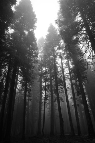
Sentinels
When we finally got back, we decided we probably had enough time to get up to Glacier Point, so we set out to drive there and maybe get in a hike on the way. Unfortunately, as we were going up into the mountains, the weather settled in again. I was getting increasingly worried about getting caught at high elevation in storm, on sinuous and slick roads. When the snow started falling, I was tempted to turn around, and probably should have, but we kept going. The entire valley was completely fogged over, and even at higher elevations, visibility was nil. I’m sure we passed some brilliant scenery (both here and on our trip to Crane Flat), but it was utterly lost to usviii.
We stopped at one trailhead my wife was excited about. However, it had just started to snow again, and snow covered the ground and rocks, with ominous clouds in the distance. I think I disappointed her by calling it off, she was very excited about seeing some geologic feature or another, but to me it wasn’t worth the risk of jumping around on slippery rocks at high altitude, since we didn’t know what else was comingix. As I was explaining this, I was trying very ,very hard not to let it show that the flock of Mountain Chickadeesx that was flying around was tempting me to go with her anyway.
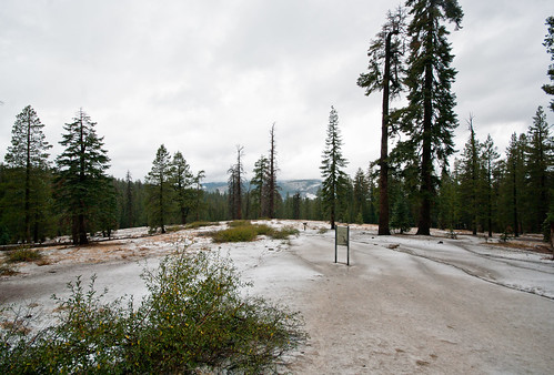
Snow at the Trailhead
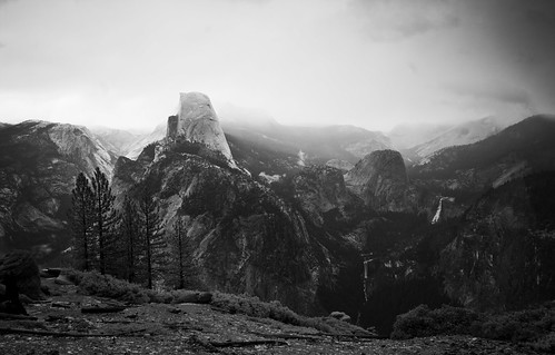
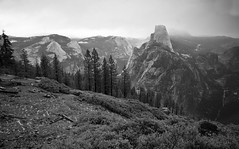
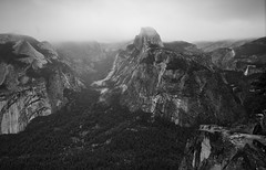
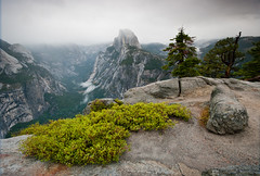
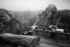
So we continued on down the road to Glacier point, stopping at the Washburn Point overlook along the way. While it’s not quite the panorama of Glacier, I thought the view from Washburn was more…austere in some way. The scene in front of us, after miles of tree lined roads dark and slick with snow, was staggering. The whole of the mountain ranges surrounding the valley laid spread out before us. The Valley was tiny, insignificant. There was a hush over the place…the sort of almost-silence that shadows the high places of the world. Not silence, but the lack of disturbance…the soft singing of the wind, uninhibited by tree or rock, flowing over the cliff face. After spending all morning in the thundering presence of the waterfalls, to see them gushing silently beneath us was an odd juxtaposition. The clouds settled over the mountains and raced down into the valleys like children at play, chasing each other across the landscape against the backdrop of a white winter sky. Somehow, even though every picture we’d seen of the place was vibrant in bright colors of morning or sunset, this grey and white panorama seemed fitting to the immensity and timelessness of the place. The rain/snow continued to pelt down now and again, and since I had not changed out of my flip-flopsxi, my stay at Washburn was agonizingly brief. The view from Washburn on that specific day in that specific light and weather is easily one of the natural moments that are most indelibly impressed on my memoryxii. Near Washburn Point there was a small ranger house, and all I could think was how simultaneously wonderful and horrible it would be to live there…wonderful in that this amazing place is at your doorstep, and horrible lest it lose its impact through seeing it too often.
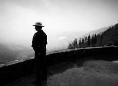
Washburn Point Vista, Washburn Point Landscape, The Sentinel (NPS Ranger)
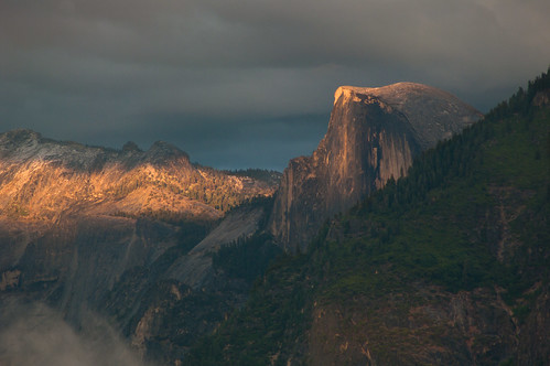
We tore ourselves away from Washburn Point and finished the drive out to Glacier Pointxiii. At this point, the light was starting to dim, although sunset was some time off. The clouds had darkened into an ominous mass, limiting what little light had been filtering through the white mass of clouded sky before. We scrambled up the rocks to the Point, and the Geology Hutxiv. At the extreme end of the point, the views of the Valley were fantastic, but soon much of the surrounding mountains were in dense cloud cover. The Half-dome profile was immense, and seemed much closer than Washburn, and the storm light turned everything into a silver gelatin print, with silvery landscapes glinting below. Ansel Adams would have gone mad trying to figure out where to turn his camera first. I’m glad we made the trip, even with its heart-racing moments. The views here are literally indescribable in any way that would truly denote the sense of scale, other than the somewhat cliché description of feeling like one was at the very top of the world, high in an ancient place. It was also really, really cold.
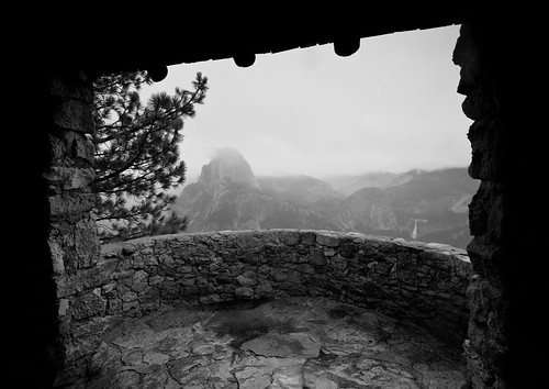
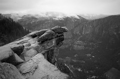
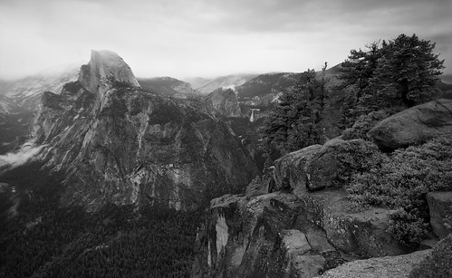
Half Dome from Geology Hut, Glacier Point Vista(6), Glacier Point Vista(2), Glacier Point Vista(3), Glacier Point Vista (4).
As the light got dimmer, we reluctantly left to return to the Valley. Our decision to make the trip, and even our decision to get gas, ended up being serendipitous…on our way back, we decided to stop one last time at the Tunnel Viewxv pull off. Our timing was exquisite. Just as we pulled in, the clouds that had chased us down the mountain began to light up. At first there were just rays of stray beams here and there, then light began to pour between the cloud cover and the mountains. By the time we got out of the car, clouds had poured in around us, and were glowing, suffused with golden light. I can’t speak to what being in the physical presence of God or deity of your choice should be like, but I’m fairly sure this is as close as I’ve gotten in terms of sheer sensory assault. No sooner had I gotten my tripod set up, then the gloomy valley suddenly lit up, ablaze in the last light soaking through the clouds. The fog almost exploded into an array of color, blazing its way down the valley. I had assumed that there would be no chance for photography, under the dim dark clouds, so I was caught completely off guard. For the other photographers there, patiently waiting, I'm sure the experience yielded some once-in-a-lifetime pictures. Even unprepared, it was amazing to watch the light pan across the valley. El Capitan glowed brilliantly orange-red, and then the Merced, now full and running, glinted back deep blues and greens as the light swept over it. Finally, as the sun slipped behind the mountains, the last rays broke free and lit up Half Dome in the distance. For what was supposed to have been a wasted day, it ended up being an incredible end to the trip.
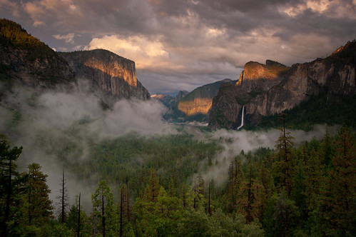
Last Light on Half Dome, El Capitan in Last Light, Bridal Veil Falls at Sunset, Evening Panoramic – Tunnel View
We got back too late to really make food ourselves, and were tired of pizza from Curry Village. Having survived the wrath of the Curry Buffet morning after on my hike up Half Dome, the rest of the cheap dining options seemed unfortunate for our last night there. So even though we’d eaten there the night before, we went back to the Mountain Room restaurant. Again, I felt guilty about spending my National Park time eating at a luxurious restaurant instead of some exercise in gritty self-reliance. I comforted myself by ordering a local beerxvi to go with my pork picatta and corned beef and cabbage soup. Kate one-upped me and got the steak.
After this last meal, we got back to Curry Village and reluctantly packed up our tent cabin, damp clothes and all, in order to leave the next day.
Next up, our last Day in the Park, and a walk in Ansel Adams’ shoes.
NOTES
iI say “rains” but what I really mean is that somewhere, someone greatly angered the powers that be, and the firmament of heaven tore open and unleashed its wrath upon us for seven straight hours of unrelenting deluge, cataclysmic skyfire and mountain-shaking thunder.
iiMy wife made a bit of fun of me for carrying several dozen feet of ranger cord in my backpack. After a week of intermittent rain and hiking sweat, being able to string up a line or two to let things dry proved invaluable. I am utterly convinced that of all the potential fancy camping gear available, the most absolutely essential continues to be: 1) a good length of ranger cord, 2) a good knife, 3) a small supply of high proof alcohol (not just for drinking, but for starting wet fires, as an antiseptic, and a million other uses), 4) a small roll of duct tape. I am pretty sure, given these 4 items, I would be completely secure in the case of major catastrophe up to and including a low level zombie apocalypse.
iiiAs they usually are that time of the year, 1000 year storms notwithstanding.
ivWhat wonderful irony…I can only picture Muir standing in awe of the mountains around him….as he chops up tree after tree. ..
vOr fortunately, from the environmental perspective…
viWhy we did this that day, instead of getting it on the way out the next day, I can’t recall….we must have been extremely low on gas….but still…it ended up being a ridiculous waste of time, as it took over 2 hours to get there and back, and we headed out that way the next day.
viiIncluding nearly being hit at high speed by a tourist bus.
viiiWe did, however, get to see amazing color along the roadsides, as patches of the bracken ferns were blaze orange among the dark green and grey landscape.
ixTo her credit, she didn’t guilt trip me too much about it, although I could tell she really wanted to go. I have a feeling she still thinks it wasn’t so bad and we could have done it, but doesn’t say so. To be honest, I still think we shouldn’t even have considered it in that weather, but I don’t say so. Thus the detente of marriage resumes.
xA new species for me
xiFlip flops + 7000 feet elevation + snow melt puddles + incredibly vista = mind-blowing sensory overload.
xiiPart of me was saddened when none of my rushed pictures turned out truly anything like what I saw there, but another part of me is fairly glad that my memory will have to serve me, instead of slowly melting into the mold of some picture.
xiiiGlacier actually is situated almost directly over our campground area in the valley. In fact the trail head was not far away. Of course, while it was close horizontally, it’s an almost completely vertical ascent. The drive to get to Glacier Point swings far to the west and south, only then to wind back up to the point. When jetpacks are a reality, I can only guess its visitation will quadruple.
xivWe were unsure if the geology hut was so named because some crazy hermit geologists lived there at the top of the world (my theory) or just that it was an old stone structure that now showed some geology information. Regardless of reality, I choose to believe the former.
xvOne of the most popular views of the Valley, looking almost straight down it. In previous days we’d been there in horrendous light. Even then it had been a fantastic scene.
xviA must anytime I camp anywhere. Part of the fun is getting the local experience. My top local beer experience so far was the “Polygamy Porter” I had in Utah.
2 comments:
Again, beautiful photos. I can honestly say that I will probably never hike Yosemite, but your photos kind of make me want to.
Many Thoughts:
Polygamy Porter!?! - Now I am a beer light weight, but I have often said that my favorite beer is determined not by type but by proximity. French wine makers talk about terwar - the taste of a place - I love local beer.
The Geology Hut - I love it.
On tents - I consider myself a relatively accomplished back country adventurer. But that said, I think discomfort for its own sake is silly. A tent is a fantastic tool if it allows you to get several days into a wild place and away from people. But if not, sign me up for a hotel or a fun tent-cabin. Of course, Camp 4 does have a unique culture to recommend it.
That said, I actually appreciate how accessible Yosemite is. I mean, it really is 'ours' in the large sense of that word, not just 'ours' in the 'people who have similar world view to Muir' sense of the word. I loathe the crowds, but respect the vision for giving them access.
My list: Duct tape (I keep it wrapped around my water bottle and once fixed a fellow hiker's boot blow out with it), rope, knife, lighter, paper and pencil (for an emergency of insight), and a compass.
Also, while these pictures are amazing as usual, I generally think pictures need to be scored on a ‘degree of difficulty’ scale. A photographic artist proves his/her stuff by finding beauty where it is otherwise overlooked. These photographs of one of my favorite places are sublime…but your standing as an artist was established by your repeated ability to capture aesthetic wonder in Texas.
Also, I am glad you got to see the waterfalls flowing. Yosemite falls has a lower time of concentration – so no October base flow – but it will put on a show if it rains.
Post a Comment